
UAS event surveillance & Sentry V4
Don't wait for an unwanted drone incident to expose your vulnerabilities. Constant drone detection coverage you can actually rely on — as a service at your event, or as a unit you own.
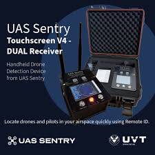
UAS Sentry Touch Screen V4
A portable, professional Remote ID detection receiver with two independent radios and dual-band coverage. It picks up Remote ID broadcasts on both 2.4 GHz and 5.8 GHz — which matters, because single-band receivers miss a meaningful share of the aircraft in the air.
Key highlights
- Two independent Remote ID radio receivers
- 2.4 GHz + 5.8 GHz detection, including Skydio and DJI Avata Version 1
- Touch screen with QR codes for quick access to drone and pilot location
- Internal GPS, adjustable audible alarm, and bright adjustable LED alerts
- Geofencing: circular geofence on-device plus polygon geofences
- Cloud upload over Wi-Fi or LTE via iPhone relay — no LTE fees, ever
- 12+ hours of continuous operation on the internal battery
- Works with the free UAS Sentry iOS app
UAS Sentry V4
Checkout is handled by PayPal. Questions before you order? Call (205) 210-9477.
Flight path generator
Turn a UAS Sentry detection log into a Google Earth Pro flyover. Drop in the CSV you exported from UASSentry.com and get back a KML with two synchronised tracks — the drone's path through the air and the pilot's position on the ground — both playable on Google Earth's time slider.
How to use it
- Export the log Sign in at UASSentry.com and download the detection log for the flight you want as a CSV.
- Generate the KML Drop that CSV above and hit Generate. The file downloads straight to your machine.
- Open in Google Earth Pro File → Open, pick the KML, then press play on the time slider to watch the flight and the pilot move together.
Reading the result. The yellow track extruded to the ground is the aircraft; the figure marker is the pilot's reported position. Where the two diverge is where the operator was standing well away from what they were flying.
Works with the standard Sentry export columns. Drone altitude uses AGL above the takeoff point where the log has it, and falls back to MSL. Nothing is sent to a server — the conversion runs entirely in your browser, so the log never leaves your device.
Or hire it for the day
If you would rather not own the hardware, we can bring detection coverage to your event and run it — alongside aerial coverage, or on its own.